Eden Valley Villages
Eden has some lovely villages to explore.
Ainstable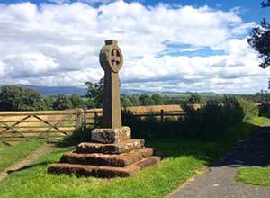
One half-mile east of the river Eden is the village of Ainstable. Its Viking name was Einstapli. Later it was variously spelled Ainstaple, Eynstable or Aynstapelith. The name supposedly evolved from 'On-Steep-Hill', related to the small hill on which the village sits close to the Pennine moors.
The village church, St Michael, sits on land where an earlier church and a nunnery were. It is a rebuilding of 1872. The church is made up of a nave and chancel. A small square tower at the north-west end has been demolished.
Inside the church are a Norman pillar piscina and effigies dating back to the early 15th century. The churchyard is set off by a lych-gate. Walks and fishing are available in the area. Near the village is a set of stone circles, Broomrigg Plantation, dating from the early Bronze Age. The remains of four red sandstone stones in an arc, a low henge bank, and cairn circles are located in a forest.
Ainstable was the site of a Benedictine convent (the manor of "Nunnery"). This is said to date from the reign of William Rufus. However, Pevsner says that "the earliest reference is 1200. The nuns were so harassed by the Scots that in 1480 they had to reinvent their own charter, spuriously dating their foundation to 1089 and William Rufus." After the closure of the monasteries, the convent building became a private home, held for many years by the Aglionby family.
Armathwaite
Armathwaite lies on the River Eden and the Settle to Carlisle Railway has a railway station in the village.
The parish church of Christ and Our Lady was formerly a chapel-of-ease in the parish of Hesket-in-the-Forest. It is one of the smallest parish churches in England.
By the 17th century the original chapel had become ruinous. It was rebuilt before 1688 by Richard Skelton of Armathwaite Castle. It consists of a chancel and nave with a wooden roof and a small western bell turret.
John Skelton, poet and tutor to King Henry VIII, is believed to have been born here.
Croglin
Croglin is a quiet picturesque fellside village between the Pennines and the River Eden. The village is about 14 miles (23 km) south-east of Carlisle. The surrounding land is used for agriculture, mainly sheep. A small river, Croglin Water, flows through the valley down into the River Eden.
A village has existed in this location for a long time and may originally have been two separate hamlets. There has been a church on the current site since the Norman period. However, the present building, dedicated to St. John the Baptist, was erected in 1878 to a design by J. Hewison of Edinburgh.
Because of its proximity to the Scottish borders, the village was often raided by the Border Reivers in the 15th century. The lower two stories of a pele tower still survive. These were incorporated into the house formerly known as Croglin Vicarage, now The Old Pele, a testament to that need for defence.
The tale of the Croglin Vampire is associated with the area, you can read more about this on our Myths and Legends webpage. Croglin Toys is based in the village.
Gamblesby
Gamblesby is a village near Melmerby, which appears first in written records in 1177 as Gamelesbi, and in 1212 as Gamelesby.
There are several large and very beautiful houses, also there are others that are smaller but all with gardens. Plenty of land surrounds the area which all has either life stock or crops for farming. It is a friendly and quiet village, usually for younger children and old age pensioners. This is a medium sized village which has a quiet road passing through which leads to Unthank, Glassonby and Melmerby.
There is a network of footpaths linking Gamblesby with other little villages around the valley. Nearby is Alston, one of England's highest market towns.
High Hesket
High Hesket is a small group of houses, a school, an inn, and a church along the A6 road north of Penrith.
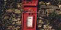
St Mary's church is made up of varying features from different centuries. The arched windows of the nave date from 1720, while the east and north aisles are from Victorian times. The chancel arch is 13th / 14th century. Features include a 17th century double bellcote and 18th century west porch. Bodies of people who died from the plague were sent here from Carlisle for burial. The church was built on the site as a direct result. A mausoleum of the Parker family lies in the churchyard.
A castle, Hewin, once lay on the north-east shore, but its remains have vanished. It was supposedly a stronghold of Swaine, a Cumberland king. Viking arms were discovered near the village inn.
Kirkoswald
Kirkoswald lies in the Lower Eden Valley, about 9 miles (14 km) from Penrith. The village is usually referred to locally as KO.
The village's name means Church of St Oswald and the parish church is dedicated to Saint Oswald, King of Northumbria. The body of Oswald is believed to have been taken through the village. The church lies on the southern edge of the village overlooking the River Eden close to the bridge which connects Kirkoswald to Lazonby. St Oswald's Church is unique in having a 19th century bell tower on top of the hill, 200 yards from the church itself. Parts of the church date from the 12th century. The chancel was added in 1523, when the "College" was founded by Thomas Dacre, 2nd Baron Dacre and his wife. A sacred spring lies under the nave of the church, and a well is found on the west wall.
One of Kirkoswald's most splendid buildings is the "College." Its name recalls the days when St Oswald's Church was a collegiate church. Originally built in 1450 as a Pele Tower it became home to the Fetherstonhaugh family, after dissolution in 1547. The family had previously lived at Featherstone Castle in Northumberland.
Kirkoswald was given its market charter in the 13th century. The village held a market before it was moved to Lazonby and Kirkoswald railway station after the creation of the Settle to Carlisle Railway line in 1876.
Langwathby
The village of Langwathby is on the A686 running between Penrith, Alston and Hexham. Claimed to be one of the ten most scenic roads in the World.  The village lies on the banks of the River Eden.
A large village green occupies the centre of the village. The Settle to Carlisle Railway has a railway station in the village.
Beside the village green is St Peter's Church, built in 1718, but with some parts inside dating from medieval times.
The Bailey bridge over the River Eden was built in 1968 to replace a sandstone bridge that had been swept away by floods. The bridge was meant to be a temporary measure. It is listed in the Guinness book of Records as the longest lasting temporary bridge in the country.
Lazonby
Lazonby is a village in the Lower Eden Valley of Cumbria. Lazonby is about 8 miles (13 km) north east of Penrith and 24 miles (38 km) south of the Scottish Borders.
The railway station of Lazonby and Kirkoswald is conveniently situated for Lazonby, with Kirkoswald about a mile to the east. Once this was one of the 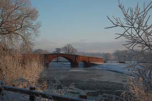 busiest goods stations on the line, dominated by livestock traffic. Sheep were brought from Scotland, rabbits were sent to Yorkshire, and fish from the River Eden were sent to London in special boxes.
The village has a very fine Church - St Nicholas by Anthony Salvin, built in 1863 at the expense of the Macleans of Lazonby Hall. A notable feature is the woodwork executed by Canon B W Wilson, Rector 1877-1920. This can be seen on the south door, north vestry door, the pulpit and the chancel, organ and tower
screens. There is an imposing unornamented wheel cross at top of the graveyard, possibly 10th century. There are 4 bells hung for full-circle ringing.
Between Lazonby and Kirkoswald, a fine sandstone Bridge crosses the River Eden. A small car park nearby gives access to one of the Eden Benchmarks - 'Cypher Piece' by Frances Pelly.
There is a swimming pool in Lazonby.
Little Salkeld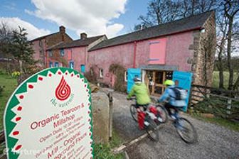
Little Salkeld is a small village, a few miles to the north east of Penrith and within the parish of Hunsonby.
The manor at Little Salkeld was confirmed by King Edward I in 1292. It is believed to be the original home of the Salkeld family of landowners.
Little Salkeld Watermill was built in 1745 and is a traditional English 18th century water mill. It is Cumbria's only watermill still in full operation. Its organic bread and all-purpose flours are available in specialist shops throughout the UK.
The privately owned Salkeld Hall is the village's largest house; built in the 16th century incorporating earlier walls. The village contains a vicarage but no church - it was built for Addingham parish church one mile to the north near Glassonby.
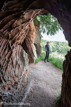 Popular with walkers it is the closest village to Lacy's Caves and Long Meg and Her Daughters. It lies on the C2C Cycle Route.
Low Hesket
Low Hesket is on the A6 road 8.5 miles (13.7 km) south of Carlisle, Cumbria. This is a former
Roman road, and a milestone from that era has been discovered there inscribed IMP C FL VAL CONSTANTINO P F INV AVG. This expands to Imperator Caesar Flavius Valerius Constantinus Pius Felix Invictus Augustus. It dates from the time of emperor Constantine I, who ruled from 307 to 337.
Low Hesket forms part of the civil parish of Hesket, which, in turn, is part of the district of Eden.
Melmerby
Melmerby is on the A686 road leading from Penrith over Hartside Pass to Alston. It is supposed to have taken its name from its having been the residence of Melmor, a Dane who lived hereabouts in the ninth century.
Nestling at the foot of the Pennine scar, Melmerby is typical of a number of picturesque fell side villages which lie along the eastern edge of the Eden Valley.
The village consists of red sandstone buildings overlook an 11-acre green, where the villagers still have traditional grazing rights. Horses now find a meal where there were once flocks of geese that gave rise to a feather pillow and mattress making industry.
The A686 from Penrith in Cumbria to Corbridge in Northumberland was chosen by the AA Magazine as one of their 'Ten Great Drives'.
From Melmerby, the road climbs the Hartside Pass to a height of 1904 ft. From here there are magnificent views across the Solway Firth to Scotland. This long and steep climb also forms part of the Sea to Sea Cycle Route. To the south, Melmerby lies only 4 miles from Langwathby.
Nearby is the Church of St John the Baptist, a 13th Century building of red sandstone. Some of the windows, all of which are plain, may be as old as 600 years.
Melmerby has one of the 'Sheepfolds' by Andy Goldsworthy. The 'washfold' is at the south end of Melmerby Village, beside the A686. The fold can be seen by parking above the village green. Access to the fold is over a small footbridge beneath which Andy Goldsworthy has carved a 'dub' stone set in the river.
In the village stands Melmerby Hall, a Grade II listed manor home, which started as a defensive tower in the 1300s. It is set within its own sandstone walled grounds, which are entered through an arched gateway at the edge of the village. The grounds include an archery lawn, walled vegetable gardens and a Victorian castle folly at the foot of the lawn. The forested grounds extend for 20 acres, and incorporate a small tributary of the River Eden. Inside are a number of unusual features. These include a priests hole, an enormous inglenook fireplace and doorways through old fireplaces.
The first mention of the existence of the Hall is in the reign of Edward II (1307-27) when it was owned by John de Denum. It passed some time later to the Threlkeld family. They extended the tower in the 17th century and again in the 18th century in a Georgian style at the front of the house.
The Village Bakery is in Melmerby.
Plumpton
Plumpton is a small village about 4 miles (6 km) north of Penrith. The earthwork remains of a substantial Roman fort can be seen at Plumpton Wall, on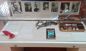 the Roman road south from Carlisle. The fort was known in antiquity as Voreda.
Percy Toplis 'the Monocled Mutineer' was shot dead by police at Plumpton. A blue plaque to mark the spot now stands at Romanway Farm. Toplis' belongings, including his monocle, were handed to Penrith and Eden Museum where they are now on display.
Renwick
Renwick is a small village, located north east of Penrith between the A686 and B6413 roads.
One mile south-east of the village in the hamlet of Haresceugh are the fragmentary remains of Haresceugh Castle. The site of which is now occupied by a farmhouse. Two sections of walling remain from the castle. There are no amenities in Renwick, the nearest facilities are in Kirkoswald. Renwick is a small, close-knit community and has an active farm.
According to local legend, the village was terrorized by a cockatrice in 1733.
The village church, All Saints, built in 1845, took the place of a 1733 church. Remaining from the 1733 church is a two decker pulpit. The church was built on the site of one founded in AD600 by missionaries. The 1845 church is in the Norman style and contains stained glass windows. A Methodist chapel dates from 1818.
Sign up for our e-newsletter

Celebrating 150 years of the Settle-Carlisle li...

Integrated ticket allowing seamless travel acro...
In need of a conference venue?