Accessible Walks - suitable for wheelchairs and pushchairs
Smardale Gill Nature Reserve walk, near Kirkby Stephen (Cumbria Wildlife Trust)
Smardale Gill Nature Reserve, near Kirkby Stephen occupies a 6km/3.5 mile section of the disused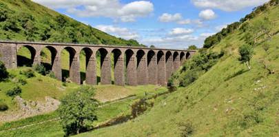 railway line which once ran from Tebay to Darlington. The northern end of the nature reserve includes the steep wooded slopes of the gill carved by Scandal Beck. South of Smardale Gill Viaduct the character of the nature reserve changes and you find yourself in open rolling countryside typical of the area.
Suitable for Buggies, wheelchairs and dogs on leads. (NY740082).
- Smardale Gill Nature Reserve (3.2miles/5.3km)
The Viaducts Round
The complete circular walk, known as the Viaduct Round, starts at the centre of Kirkby Stephen and incorporates local footpaths, totalling about four miles. The portion along the old railway over the viaducts is easily accessible to walkers, cyclists and horse riders. With graded level surface it allows good access for visitors of all levels of mobility.
- More information is available on the Eden Viaducts website.
Get Outside in the Westmorland Dales
A 20 minute film 'Get Outside in the Westmorland Dales' was launched in October 2021. The film can be viewed on YouTube.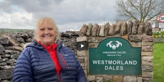
The film is a celebration of what the Westmorland Dales has to offer for everyone, including people with disabilities, whether they are local to the area or a visitor. The aim of the film is to encourage people with disabilities and long term illness who live in the Westmorland Dales to get outside and be active.
Join Debbie North as she explores the area lies to the north of the Howgill Fells in Cumbria, extending over 200 sq km from Maulds Meaburn in the north to Tebay in the south-west and Ravenstonedale in the south-east. You can read more on the film launch by visiting Debbie North's website.
Accessible Walks can be found on the Access the Dales website and include Stile Free walks.
Penrith Access for All Walk
An Access for all Walk leaflet has been produced by the Rotary Club of Penrith. The route has been chosen to make the walk accessible to all, including those with disabilities. It takes about 1½ hours to complete the full tour, but there is ample scope to tailor the route to suite individual preferences.
Ullswater
The Lake District National Park have created a series of walks around The Lake District - Miles without Stiles. These are suitable for people with limited mobility. This includes a route starting from Pooley Bridge, one around Brotherswater and the recently updated Threlkeld to Keswick Railway Trail.
- Miles Without Stiles: Pooley Bridge to Gale Bay - (1.8 km / 1.1 miles)
- Miles Without Stiles: Dunmallard Wood, Pooley Bridge - (440m distance)
- Miles Without Stiles: Brothers Water - (3.75 km / 2.3 miles)
- Miles Without Stiles: Threlkeld to Keswick Railway Trail - (10km / 6.2 miles)
South Tyne Trail, Alston
On The South Tyne Trail at Alston there's a 1/4 mile section of well-surfaced path leading from the South Tynedale Railway Station. It is easily accessible from the car park and riverside picnic site. The footpath continues down the South Tyne Valley adjacent to the narrow gauge railway. The South Tyne Trail leaflet is available from Alston Tourist Information Centre.
The Skelton to Unthank Footpath
The Skelton to Unthank footpath is 1 mile long with a 1.5 mile post at the end of the all terrain path before the large field. The path to Unthank continues straight across the field. Aim for the large tree and the field gate on the other side.
Skelton village can be accessed of the B5305 from Junction 41 off the M6. Parking is available at the Village Hall car park on the right as you enter the village. For access to the path, follow the sign to the Church. Access to the path at Unthank is best done from the Upfront Gallery where parking is available. A short walk takes you to the sign post at Nelson Square.
Sign up for our e-newsletter

The Tour de France is coming to Cumbria in 2027.

A new 120 mile Westmorland and Furness Way will...
In need of a conference venue?